By Kyle Krupa, Interpretive Ranger at Pawtuckaway State Park
Buckle in, folks. Today’s post is a long one.
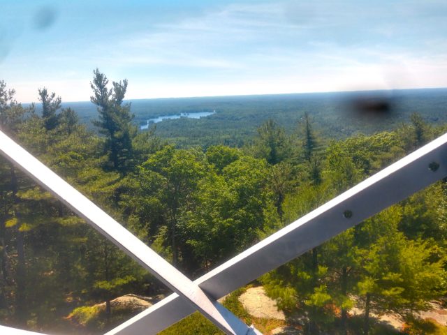
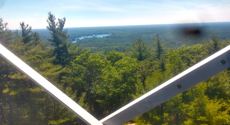
For outdoor enthusiasts living on the southern side of the state, the caldera mountains of Pawtuckaway are some of the most accessible and rewarding summit’s for a casual weekend day hike. From the top of South Mountain (The most traveled of the three sister peaks) An operational fire tower offers views stretching as far south as the grand skyscrapers of Boston, to the rocky Portsmouth coastline, and as far north as the state’s pristine central Lake’s region. (You gotta make it up here on a haze-free day for some of these views!) While Monadnock might hold the title of the most popular mountain in the state, for my money, a trek up to South Mountain can be just as rewarding and enjoyable for someone just looking to get up above tree line for the day.
My work background is mainly in trail restoration (I’ve only recently transitioned into doing more educational outdoor work.) and consequentially I spend a lot of time appreciating the state of the trails I hike. There’s very little that feels better to me outdoors than a comfortable, readable trail to explore. If a trail’s well maintained, then you find yourself with a lot more time and energy to focus on the beautiful world surrounding you and less time stumbling over rocks and slogging through mud. That all being said, I’ve got some words for the trail up to South Mountain. Not because I think the state of the trail is particularly awful, quite the contrary. It’s in my opinion that Pawtuckaway’s Mountain Trail is an excellent case study for people who are interested in or curious about the surprisingly deep world of trail work and maintenance.
Needless to say, I’ve got a lot of love for the Pawtuckaway peaks. They’ve been a focal point of my adventures in southern New Hampshire for several years running. Being this year’s Interpretive Ranger for the park, I have the (at times tiring) joy of spending a lot of my time going up and down the park’s most elevated landmarks. And in my endless uphill walks, I certainly love to pay great attention to the paths that wind me through the deeper reaches of the park.
I find that the world of trail conservation is often times not well understood by the general public. Sure, many of us walking through the woods or taking strolls through a city park have come across the occasional volunteer group rebuilding a section of the path or constructing a new footbridge over a stream but I think sometimes we don’t take that moment to consider the intricate planning that goes into making a trail something that is both comfortable for users but also safe and stable for the environment. A footpath along the side of a lake may be beautiful and a wonderful spot for daytime joggers, but trails made too close to a lake’s edge may disrupt the crucial riparian barrier protecting the water quality, wildlife and stability of the shoreline. In time, the water run off and traffic wear from that scenic path may whittle the ground around it until the entire bank begins to collapse, destroying the trail and surrounding habitat alike. Erosion, impact, longevity, and usability are all things that need to be considered when installing any sort of trail system. Much like how architects and engineers spend entire careers learning how to safely place structures into the earth, so too do the best trail workers obsess endlessly over how best to blend the allure of nature with the human desire to explore it in a way that will balance the needs of both worlds.
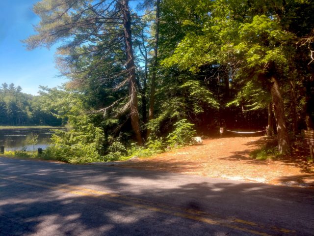
So it’s due time we talk specifically about the subject of today’s blog: Mountain Trail. Starting at the start, The access to the trailhead couldn’t be more picturesque. Tucked right up alongside the park’s main road, it’s impossible to miss. Either a short walk from the main office for day users or a quick ride from the park’s campgrounds and you find yourself on the shores of a flourishing pond. Summertime brings dragonflies wizzing across the water’s surface, lily pads dotting the pond like shamrock dinner plates across a table of murky glass and in the early mornings and late evenings, beavers coast hungrily from shore to shore, feasting on vegetation and giving a curious eye to any visitors timely enough to spot them. The trail entrance is very well marked. Several signs and a gate, along with the fantastic natural landmark of the pond, make the space both memorable and immediately apparent as the spot where an adventure begins.
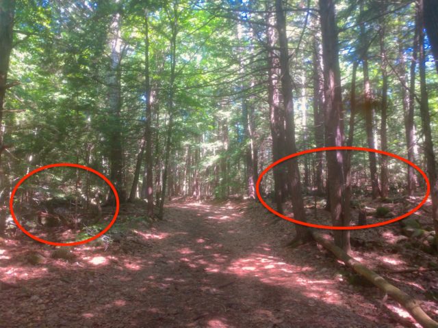
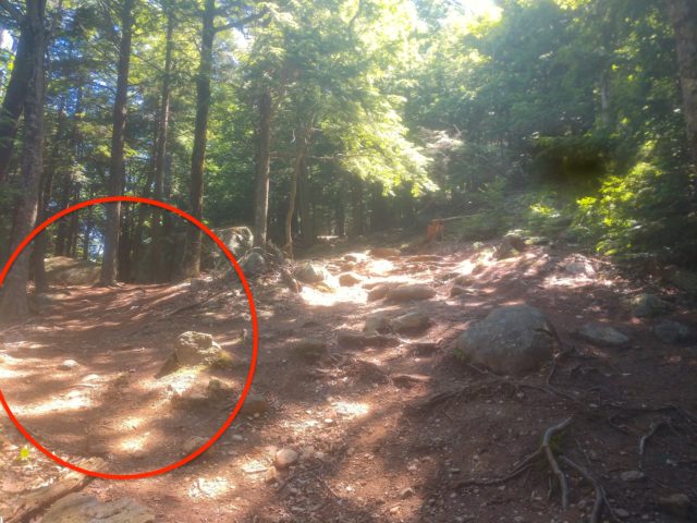
One thing you get a lot of in Southern New Hampshire are these impressively wide and level trails that seem almost signature to areas like Pawtuckaway. The majority of Mountain Trail is composed of these wider type trails and it is something of a slight anomaly, if we were to believe that the trails were made and intended for hikers alone. As one can see from the picture below, the trail shown could fit several hikers moving in both directions at once, without either groups needing to stop to let the others pass. (apologies for the poor quality of my images, the only camera I had was my chipped phone camera.) This is so for several reasons. The most contemporary reasoning is that most popular trails throughout Pawtuckaway are actually maintained for multiple user groups. The user groups most trail work is focused on are hikers, bikers, motorized vehicles like snow machines or ATVs, and of course equine (our more horsey-type friends). The trails in Pawtuckaway function differently for different user groups at different times of the year. Trails like Mountain Trail that are enjoyed mainly by hikers in the summer may be used in snowmobile circuits during the snowy winter months. Other trails like the park’s Fundy Trail typically see a variety of user groups per season, with mountain biking and hiking being popular there almost year round. When working on these sorts of multiple use trails, it’s important for workers to consider the needs and potential impact of all groups.
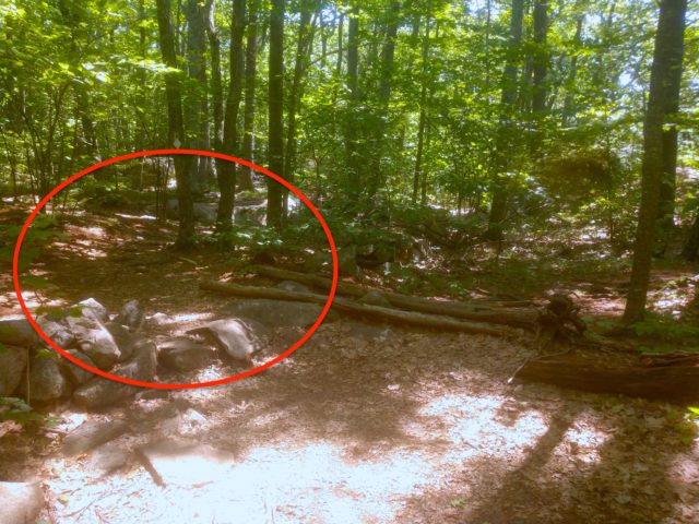
The more historical reasoning behind wider trails is also the more fascinating one, in my opinion. Many of the current recreational trails throughout Southern New Hampshire are actually based off of old farm roads from the state’s era of agricultural expansion. Now we’ve all seen stone walls lining New Hampshire forests seemingly at random. (I’ve marked them in the below image.) Most people are either aware of or can assume that these are traces of old property markers from long ago when much of New Hampshire was converted into farmland. In fact nearly 90% of New Hampshire was at one point deforested and converted into land for crops and pastures. But of course, this era wasn’t meant to last and as farms were abandoned, the forests grew back around them with only scars on the landscape remaining. These scars take the forms of old structures like stone walls and the once bustling paths between farmlands. Making the most of our past, the State Parks have been converting these once manicured roads meant for wagons and horses into recreational attractions for decades. This has streamlined the creation and maintenance of many trails throughout the park, as their foundations have been established for centuries.
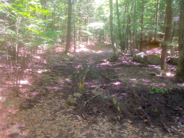
These wide trails don’t come without their problems though. Below is an image of what we refer to in the trail stewardship world as a “blowout”. Blowouts are patches of mud that form when traffic through an area combines with lack of proper water drainage and eventually begins to erode sections of trail. As the mud builds up in the center, users tend to move further and further to the sides of the trail on their ways through. While one can’t blame a hiker for wanting to avoid slipping through the mud, this creates an ever increasing problem. The mud and erosion in the center will continue to expand, as the outer areas of the trail continue to be worn down. Eventually, the trail will widen and deform until it consumes and destroys the landscape surrounding the trail.
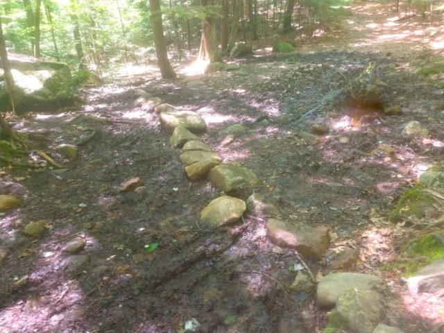
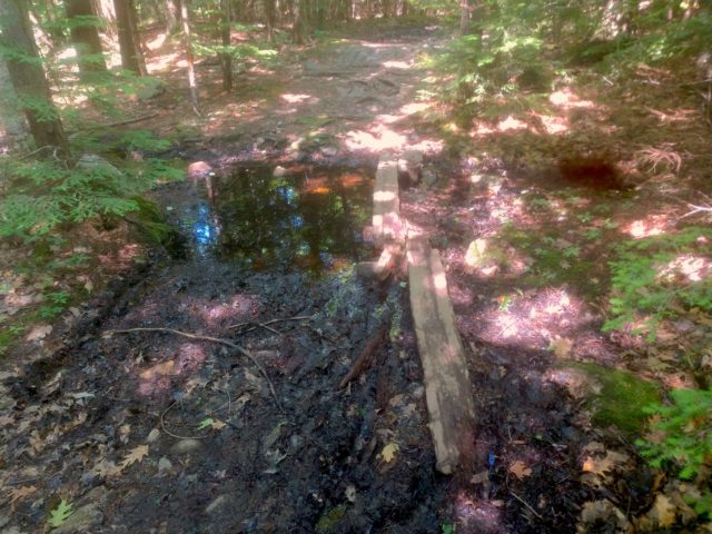
Trail workers have several ways to repair these sections of trails, depending on logistics and what resources are available. Shown below is the remnants of a drainage canal meant to redirect water from flowing down the trail and off into the woods. Irrigation is a crucial piece of trail work. with proper irrigation in the form of canals and trailside trenches, larger issues like blowouts can sometimes be avoided.
Then of course we have structural installations. Boardwalks, bridges, turnpikes, and more are all just a few options that can be considered, all serving different but similar purposes of getting traffic off the sensitive ground. Below is an image of an aging foot bridge that reminds us that while you can make smaller installations like these further up the trails, eventually, maintenance and replacements are still required.
Another common issue workers find on the trails are the infamous “social trails” pictured below. Social trails are created when groups of hikers repeatedly make the decision to go off trail and forge their own path through the woods. Social trails are often made in attempts to avoid formed obstacles like blowouts or sometimes just made by way of what less considerate hikers would think is convenient. These sorts of trails pose the obvious issue of expanding the impact of human traffic on the environment. Trails made through convenience and not the careful consideration of a conservation steward will almost always bring their own supply of problems, many times far more severe than the ones created on existing professionally made trails.
I recall a time I was out hiking Mt. Chocorua in the Whites and couldn’t help but be shocked by the number of social trails running directly up the slope of the mountain. These trails, shooting straight for the summit and blowing past meters and meters of hard laid incline trail, were quite literally tearing the soil of the mountain away from itself. Trails that run in direct slope with mountains often increase erosion tenfold, in comparison to more zig-zagged patterns you might typically see on steeper trails. If social trails like these are not constantly kept in check by workers and educators, it might mean the destruction of landscape and the eventual unsuitability for hiking on these beloved mountain paths. So If you’re ever out for a hike and have the option to walk on an intended trail or something that was made clearly out of convenience, consider helping preserve that space and maybe go the road more intended.
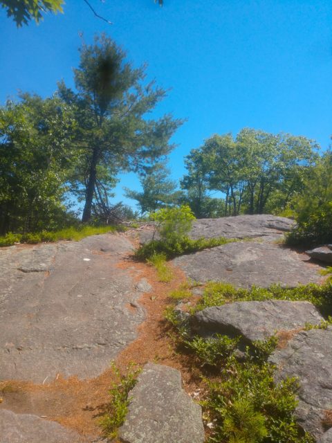
As we approach the last leg of the hike up to South Mountain Summit, I noticed this nice little spot to illustrate the visual differences between our trails based on farm roads and trails that have been laid purely from a recreational origin. Notice the difference in width and general leveled terrain, as one would step over the stone wall and onto the narrow more rocky stretch of trail. Most hiking trails made solely as hiking trails typically look more like the section after the wall-step.
Finally near the top, we have some places to talk about trail marking. While a good tread is important for your trail, the path is only as useful as the markings you label it with. Marking can be a fickle science. You want to make your “blazing” frequent enough for visitors to have confidence in where they’re heading but you don’t want to saturate your trail in it and detract from the natural beauty of an area. More open spaces like the paths near the summit can be incredibly difficult to mark properly, when there aren’t as many trees and natural barriers to turn into visually crisp corridors for hikers. Even after all my trips to South Mountain, I sometimes forget the exact way to the top and find myself accidentally wandering down a social trail or even sometimes missing the trail entirely and hiking a completely different path down from the summit.
Like most elements of trail work, blazing and improved signage is always an ongoing part of the job. One that requires the time, funding and manpower that parks sometimes simply don’t have. There is always something that needs to be done in a park’s trail system and it’s a matter of prioritization until we can start to see many smaller projects like markings addressed fully. A good trail worker needs to be constantly cognizant of their available time and resources in order to get the most important work done in way that is quality. Sometimes it can be decades before one area of trail is able to be addressed again so longevity is key in trail work.
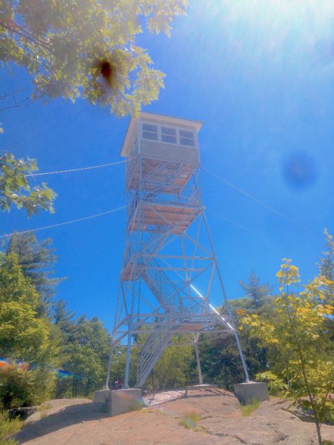
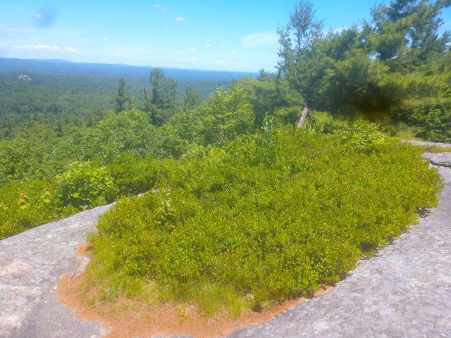
And now finally to the top! South Mountain Summit is a friendly 908 ft. above sea level and decorated with an abundance of attractions. From the seas of low bush blueberries growing amongst the summit rocks and the several bird feeders attracting an impressive diversity of wildlife, this peak is one of the most lively summits in the state. Then of course we have the iconic fire tower. Standing several stories atop the mountain’s rock face, it wasn’t until 2017 that restoration teams were able to fully reopened the lower floors back open to the public. If you’re ever up there, look for the spray painted sections of board, tagging specific pieces of lumber for workers who were assembling the tower’s new landings. Remember their hard work and that without it, we wouldn’t have a sustainable way up to these amazing views.